
Troop 17 is part of the Angle Tree District of Annawon Council. Have you ever wondered where the district name came from? It's actually from a very important historic landmark.
From the "History of Annawon Council" on the Annawon Council website:
In 1966 Annawon Council held a contest to rename the North and South Districts. Angle Tree was suggested by Gary Fish of Troop 10 N. Attleboro, and Sachem by Barry Pinto Pack 6 of Taunton. Prior to 1964 the two districts were known a North (Angle Tree) and South (Sachem) Districts. Sachem
came from a Scout reading Indian history.
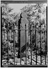
The Angle Tree Stone exists in N. Attleboro, off 19 High St, on the North Attleboro/ Plainville border. The stone marker was
erected in 1790 (during George Washington's second term as president) to replace a dying White Oak tree that was used as
a boundary marker since 1640. It was designated as the border between Plymouth Bay Colony and Massachusetts Bay Colony. It is the second-oldest such stone monument in the nation, and also marks boundary between Norfolk and Bristol counties.
The stone has been given the status of a National Monument
More information on the Angle Tree Stone, including it's exact location.
From the "History of Annawon Council" on the Annawon Council website:
In 1966 Annawon Council held a contest to rename the North and South Districts. Angle Tree was suggested by Gary Fish of Troop 10 N. Attleboro, and Sachem by Barry Pinto Pack 6 of Taunton. Prior to 1964 the two districts were known a North (Angle Tree) and South (Sachem) Districts. Sachem
came from a Scout reading Indian history.
The Angle Tree Stone exists in N. Attleboro, off 19 High St, on the North Attleboro/ Plainville border. The stone marker was
erected in 1790 (during George Washington's second term as president) to replace a dying White Oak tree that was used as
a boundary marker since 1640. It was designated as the border between Plymouth Bay Colony and Massachusetts Bay Colony. It is the second-oldest such stone monument in the nation, and also marks boundary between Norfolk and Bristol counties.
The stone has been given the status of a National Monument
More information on the Angle Tree Stone, including it's exact location.
Angle Tree District consists of units from Mansfield, Norton, Attleboro and North Attleboro. It currently has 13 Packs, 12 Troops and five crews.
 RSS Feed